
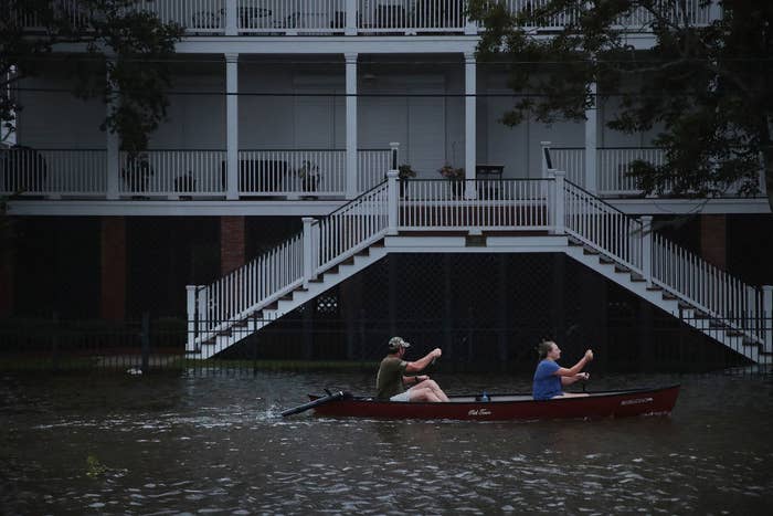
Southern Louisiana seems to have dodged a bullet with Tropical Storm Barry. Although heavy rain caused widespread flooding after the storm hit the state Saturday, the region’s two biggest cities, New Orleans and Baton Rouge, were spared the worst.
But nationwide, the threat to lives and property from rain-triggered storm flooding is escalating, with global warming spawning larger, apparently slower-moving storms, and asphalt and concrete covering permeable open ground that would have soaked up rain as cities expand.
Flooding has always posed the main danger when tropical storms come ashore, and historically, the main killer has been storm surge — a sudden rise in sea level caused by low atmospheric pressure and winds blowing onshore. But in the past three years, 75% of the more than 160 deaths from hurricanes making landfall along the US Gulf Coast and Eastern Seaboard have been due to flooding from heavy rain rather than surging seas, according to statistics from the National Hurricane Center.
Several factors are to blame. Because hurricanes gain strength over warm ocean water, and because a warmer atmosphere can hold more moisture, which ultimately gets dumped as rain, global warming is thought to be driving bigger, wetter storms. Before Hurricane Florence made landfall in the Carolinas in September 2018, for instance, researchers estimated that parts of that storm would drop over 50% more rain than it would have in the absence of human-caused climate change.
There’s also some evidence that global warming is weakening the circulation of the atmosphere of the tropics in summer, causing storms to move more slowly — although the idea is still controversial.
And when a slow-moving storm stalls over a city that is largely paved with asphalt and concrete, with few open spaces to soak up the rain, disastrous flooding can result, experts say.
These animated maps, based on satellite image–derived estimates of areas covered by impermeable urban surfaces from the National Land Cover Database, show how urban development in several cities in the direct firing line of Atlantic storms has made those locations increasingly vulnerable to rain-driven flooding.
Impermeable surfaces include rooftops, roads, and parking lots. Areas with low permeability are shown on the maps in pink, with the least permeable areas highlighted in magenta.
1. Houston
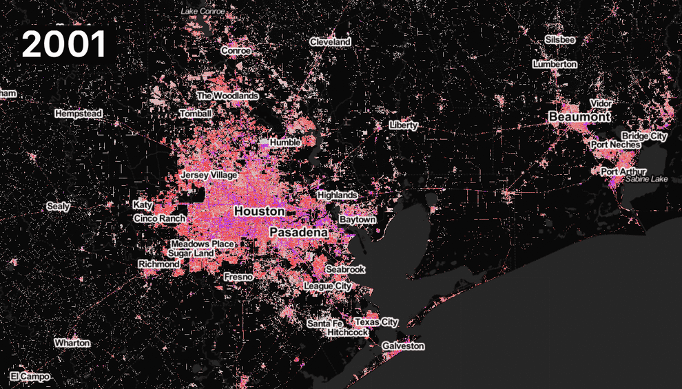
When Hurricane Harvey stalled for days over southern Texas in August 2017, it set US rainfall records — dumping more than 60 inches near the cities of Beaumont and Port Arthur.
“Harvey could be considered a rain bomb,” Eric Tate of the University of Iowa, who studies vulnerability to flooding, told BuzzFeed News.
The storm caused an estimated $125 billion worth of damage and killed 68 people — all but three of them victims of freshwater flooding. Thirty-six of those fatalities were in the Houston metro area — the fifth largest in the US with some 7 million people — which in the preceding two decades had seen a massive growth of paved surfaces, replacing natural prairies and wetlands that used to help soak up heavy rain.
“Houston is an area that has seen a lot of hardening of the watershed,” Mike Beck of the Nature Conservancy — who heads a research group at the University of California, Santa Cruz, that studies the resilience of coastal cities to storms and floods — told BuzzFeed News in the wake of the storm.
A 2015 study from researchers at Texas A&M University found that Harris County, which includes Central Houston and some of its suburbs, lost 29% of its wetlands between 1992 and 2010, largely to urban development.
“Loss of wetlands on this scale means a substantial loss in the ability of the landscape to detain and remove pollutants from stormwater,” the researchers wrote. “The results are increased flooding and degraded fishing grounds in downstream bayous and marshes.”
For Harvey’s victims, the sprawling city became an impermeable death trap, in which urban development compounded the effects of low-lying land and clay-based soils that are bad at soaking up water.
“These physical characteristics make the Houston metropolitan area prone to regular and sometimes catastrophic flooding,” noted a report on urban flooding from the National Academies of Sciences, Engineering, and Medicine, commissioned by the Federal Emergency Management Agency and published in March.
After visiting the city just before Harvey stuck, the committee that wrote the report concluded that the people most at risk included the “poor elderly, renters, minority, disabled, and non-native English speakers.”
2. New Orleans and Baton Rouge
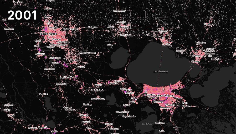
Compared with Houston, the metro areas of New Orleans and Baton Rouge, with a combined population of more than 2 million, haven’t seen such explosive development.
New Orleans, hemmed in by its protective levees, has little room to expand — and the population, now at around 400,000 for the city proper, still hasn’t recovered to the level before those levees were breached in August 2005 by the storm surge from Hurricane Katrina. (The city’s population was almost halved in the immediate wake of the storm, with many of those who fled relocating to the Houston area.)
But as a separate downpour in the week before Barry came ashore showed, a dense city like New Orleans remains highly vulnerable to rain-triggered flooding even if levees hold. Hours of heavy rain on July 10 left many streets flooded, causing Louisiana Gov. John Bel Edwards to declare a state of emergency in advance of Barry’s arrival.
3. Jacksonville, Florida
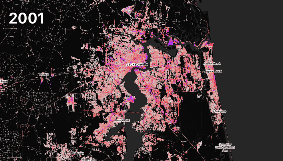
In September 2017, Hurricane Irma roared in from the south up the Florida peninsula. Surging seas had been the main concern, but the Jacksonville metro area, home to about 1.5 million people on the Atlantic coast in the north of the state, wasn’t expected to be badly affected by that. Still, the city saw extensive flooding, largely from the St John’s River, which had been swollen by torrential rain.
As this map shows, urban sprawl likely contributed to the extent of the flooding, since paved surfaces had grown significantly in the prior two decades.
4. Tampa Bay, Florida
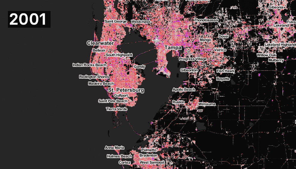
With the heaviest rain falling to the east of the storm’s eye, Irma didn’t cause major flooding in the Tampa Bay area, home to more than 3 million people. But again, urban sprawl has increased the amount of impermeable surfaces, making the cities around the bay vulnerable to rain from future storms.
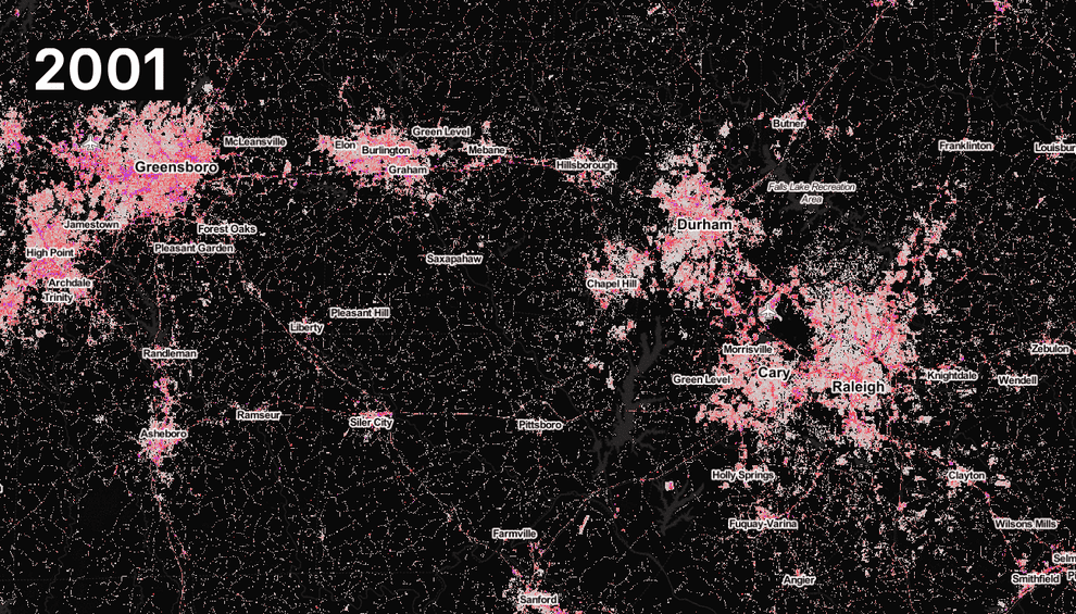
5. Raleigh, Durham, and Greensboro, North Carolina
Coastal cities aren’t the only ones at risk from flooding caused by major hurricanes.
In September and October 2018, parts of North Carolina twice experienced heavy flooding as first Hurricane Florence headed inland from the Atlantic coast, and then the remnants of Hurricane Michael, which came ashore in the Florida Panhandle, moved north.
Again, some of the state’s major cities — including the Raleigh–Durham–Chapel Hill metro area, which is home to some 2 million people — have seen a big expansion of paved surfaces, making them more vulnerable to flash flooding.
6. New York City
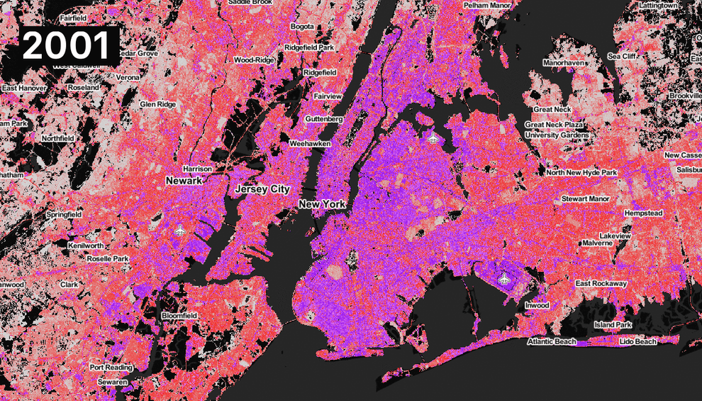
New York City, part of the largest metro area in the nation, housing more than 20 million people from New Jersey to Long Island, experienced severe flooding in October 2012 from Superstorm Sandy. That was mostly due to storm surge rather than rain. But if a major hurricane were to stall over the area, the highly impermeable surfaces shown on this map in magenta would create a big risk of flash floods.
Tropical cyclones may present the main threat, but climate change is also causing heavier downpours elsewhere. “Across most of the United States, the heaviest rainfall events have become heavier and more frequent,” according to the National Climate Assessment, with the trend being most pronounced in the Northeast and Midwest.
7. Omaha and Lincoln, Nebraska
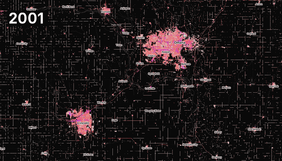
This year, much of the Midwest, including cities in Iowa and Nebraska, has experienced record flooding. Melting snow was one reason that rivers burst their banks, but heavy rains and the growth of paved surfaces in the region’s cities, shown here in Omaha and Lincoln, home to about 1.3 million people in their wider metro areas, made things worse. As climate change continues to increase the risk of major downpours, urban planners are going to have to think about how to allow excess water to drain away, experts say.
“If you neglect how you build cities, you’re going to be missing a large part of the problem,” Matei Georgescu of Arizona State University, who has studied the threats to the world’s cities posed by climate change, told BuzzFeed News.
When it comes to flooding from major storms, Georgescu said, there’s a simple prescription — albeit a hard one to achieve where space is limited: “More parks, more grass, more permeable surfaces.”
“It’s not just urbanization, it’s how we’re urbanizing and what kind of surfaces we’re putting down,” the University of Iowa’s Tate said.
CORRECTION
Hurricane Irma hit Florida in September 2017. An earlier version of this article misstated the year.