

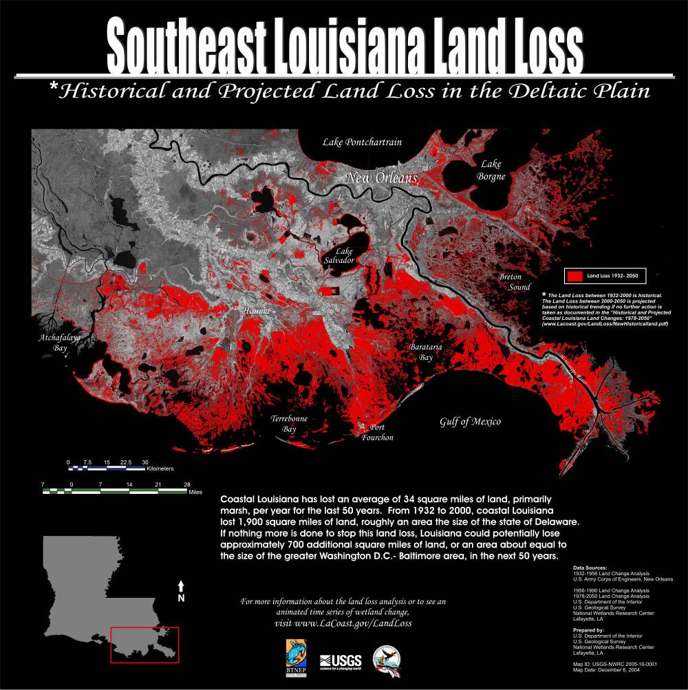
The sustainability and, indeed, future existence of New Orleans and the Mississippi River Delta depends upon a complex choreography of water, bureaucracy and infrastructure. The quandary for New Orleans can be summed up like this: how can we manage North America’s largest river in a way that mitigates seasonal flooding, while simultaneously making use of the river’s fresh water and sediments to build new land in the river’s vast but eroding deltaic plain?
But for New Orleans, the most critical components of this infrastructural system, both in the past and in the future, are located outside the city limits, in the surrounding coastal swamps and marshes. This essay will bring you to two critical locations in this watery saga, where similar techniques (the diversion of Mississippi river water into coastal basins) are applied to confront the two chief flooding threats facing New Orleans: 1) spillways to mitigate seasonal flooding on the Mississippi River and 2) river diversions to mitigate storm surge flooding from a rising and overheated Gulf of Mexico.
Spillways: infrastructure with multiple effects
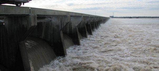
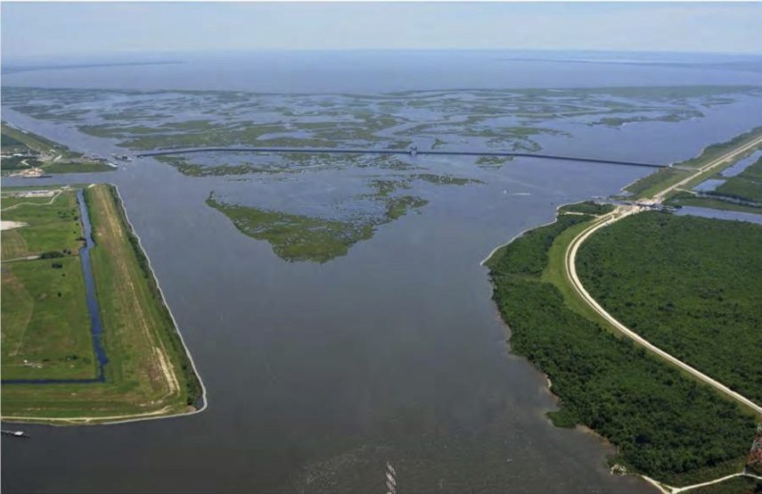
On January 10, 2016, the U.S. Army Corps of Engineers opened a major spillway just upstream from New Orleans in an effort to siphon off an unseasonably early (and likely El Nino-related) flood crest moving toward the city. Floodwater leaves the river and passes through a spillway several kilometers long before emptying into Lake Pontchartrain, a vast, brackish lagoon connected to the Gulf of Mexico.
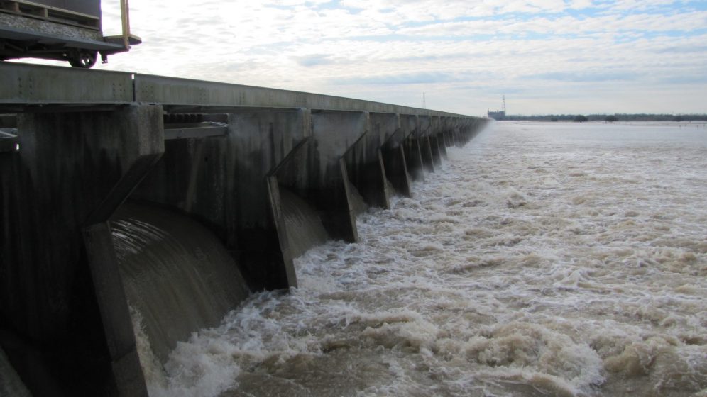
Since its construction in the early 1930s, the Bonnet Carré spillway has been opened only 11 times to prevent the Mississippi from flooding New Orleans. The 37 square km spillway is part of a comprehensive river management system implemented by the Army Corps following the great flood of 1927, which devastated many cities and towns along the river’s lower reaches. The opening of the spillway itself has become something of a civic spectacle, as was the case this time, when hundreds of people congregated on a cold morning to watch (see video of the spillway opening above). The spillway is comprised of a 2km-long concrete weir, with water controlled by an amazingly simple method: hundreds of wooden timbers, or “pins,” which can be pulled out by the engineers, allowing river water to enter the spillway. As more pins are removed, the flood crest near New Orleans begins dropping, relieving pressure on the hundreds of miles of earthen levees that line the riverbanks. The rise and fall of the floodwaters in the lower Mississippi occurs without many urbanites even noticing. The spillway, part of a wider network of similar floodwater outlets managed by the U.S. Army Corps of Engineers, has effectively kept New Orleans dry from riverine floodwaters for its entire 80 year history.
But spillways like Bonnet Carré have multiple effects beyond lowering river levels, and these effects can generate political controversies that seem to have little to do with urban flood protection. Indeed, the construction of the spillway itself involved the expropriation of private lands, and even today, disputes continue over the existence and memorialization of two slavery-era African-American cemeteries in the spillway footprint.
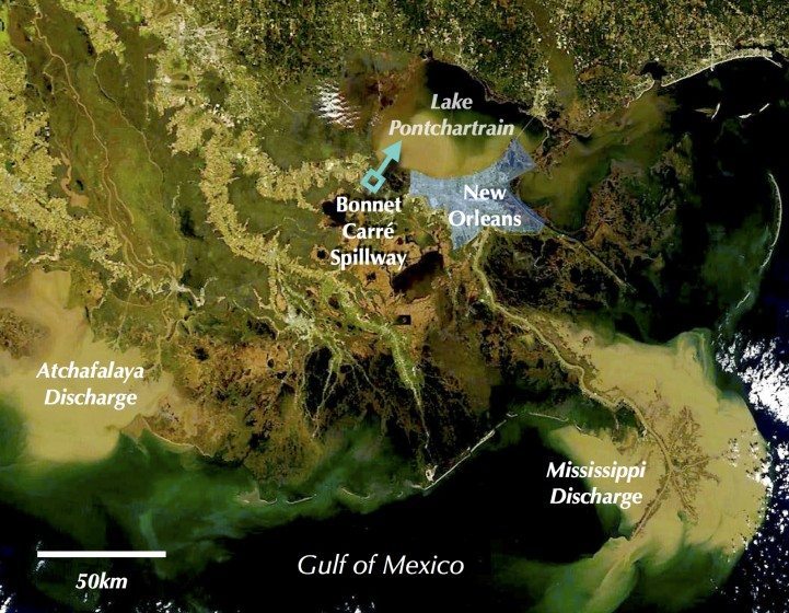
The coastal lagoons and estuaries surrounding New Orleans also see changes when the spillway opens. Lake Pontchartrain, which receives the spillway’s freshwater and sediment load, is normally full of shrimp, speckled trout, and other saltwater species. When the spillway opens, however, the entire volume of the sprawling lake is replaced by fresh river water in only about two weeks, displacing marine species with freshwater ones like catfish, alligator and invasive Asian Carp. These changes can impose limitations for fishing communities, which normally catch shrimp and fin fish in the lake. Due to the range of effects of the spillway, the politics of urban flood protection become the politics of what is “natural” in a delta ecosystem, and where certain species should and should not be in the fluid landscape.
River diversions: wicked problems of urban resilience
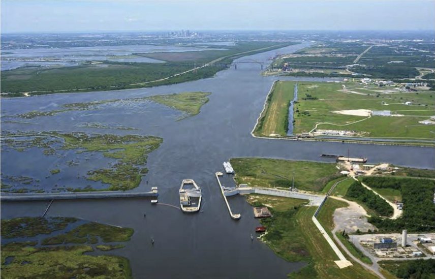
River diversions are intended to slow coastal erosion and build new land in the coastal periphery of New Orleans. There are a few existing river diversions, though they are tiny compared to the designs currently being developed as part of Louisiana’s Coastal Master Plan. For instance, the Davis Pond Diversion near New Orleans (see video below) is capable of conveying around 10,000 cubic feet per second of river water into coastal wetlands. The diversions currently being planned are much larger, rivaling the Bonnet Carré’s capacity of 250,000 cubic feet per second.
Gradually, through several projects, engineers and state officials are attempting to replicate the Mississippi’s dynamic cycles of flooding—cycles critical for preventing coastal erosion and securing the region’s future as sea levels continue rising. This will have profound effects on the ecology of the region. By 2050, it is possible that water managers, through river diversions and other strategies like dredging, will develop the capacity to strategically guide the development of the deltaic plain, creating landforms that better protect New Orleans from hurricane storm surges.
The stakes for New Orleans couldn’t be higher. As Katrina laid bare a decade a go, the city’s largely low-lying topography is vulnerable to long term inundation from storm surges. Major retrofits and upgrades in the city’s flooding defenses since 2005 are certainly positive steps in this process, but massive flood walls and pumps need to be complemented by large-scale river diversions for the city to truly develop meaningful resilience to storm surges.
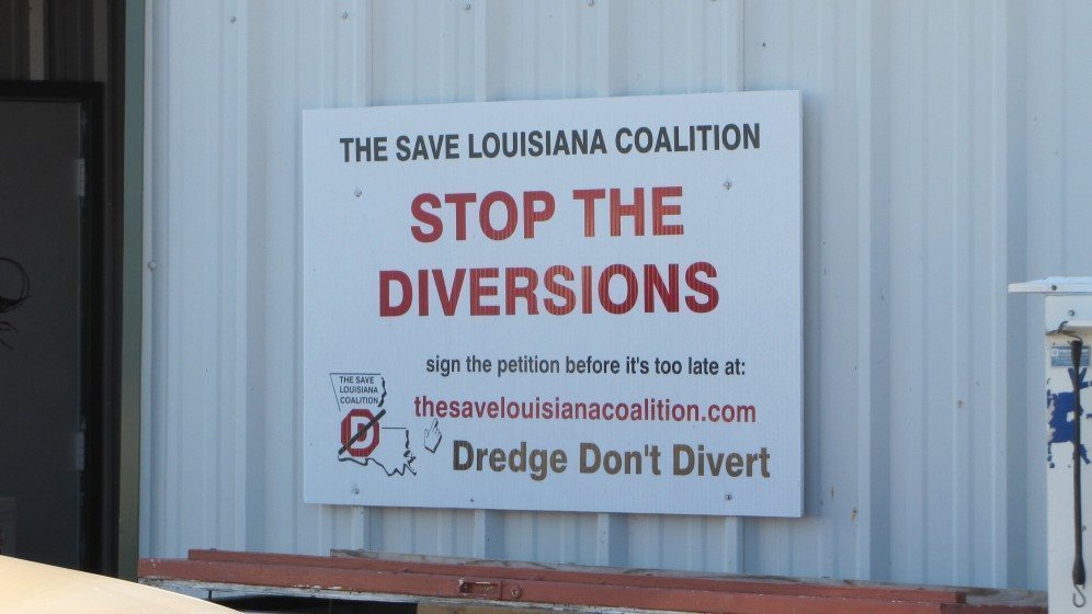
However critical river diversions might be for the resilience of New Orleans and the region, they are controversial with certain segments of the fishing industry, as well as with some coastal communities. Louisiana is home to the second largest commercial fishery in the United States, producing a third of the country’s overall harvest (Lowe et al. 2011). The implementation of an entire system of river diversions would no doubt have major implications for the region’s ecosystems, and those effects would, in some instances, impinge upon fishing practices and community life in the urban periphery. Lucrative saltwater fisheries, oyster beds and shrimping grounds will likely be displaced farther towards the open ocean as freshwater ecosystems, flush with river water and sediment, again take hold. Fishing communities, already facing strong headwinds from recent hurricanes and the 2011 BP oil disaster, can now add the wholesale transformation of the state’s southeastern coastline to the long list of challenges facing their way of life.
As such, the infrastructures necessary to secure New Orleans from riverine flooding (flood outlets) and coastal land loss /storm surges (river and sediment diversions) involve the re-working of the city’s hinterlands into a landscape better capable of absorbing both fresh and marine flooding, while placing a minimal burden on coastal communities. This is a delicate balance to be sure, and the State of Louisiana is investing a great deal of funding and expertise into the evolution and implementation of its master plan to make sure this is the outcome. That process, its successes, tensions, and failures will no doubt be instructive for scientists, planners and civil society in other coastal urban areas, where water management touches all aspects of economy, ecology and culture.
The Mississippi River Delta will be subject to major re-engineering over the next several decades, or its core population centers will be living on borrowed time. The central question here is: at what scale should the region’s resilience be assessed and enacted? As large-scale environmental planning projects become increasingly framed as ventures in “urban reslience,” the spillways and river diversions of coastal Louisiana remind us that planning for resilience at the urban scale can transform peripheral spaces into de-facto sacrifice zones (Colten, 2012), where the hazards of such projects are offloaded and communities and livelihoods can be unraveled. When dabbling in the dynamics of such massive and complex systems as river deltas, planners and scientists need to be aware that despite all good intentions, ecological transformations often generate goods and bads, which accrue differently across space and social difference. Being honest about the possibility of ecological change and community displacement up front is key—the re-ordering of landscapes is just that: it may enhance the resilience of some locales while undermining that of others. Climate change assures that this sort of dilemma is likely to become a lot more common over the next few decades, and no new buzzword or policy trend can truly cut the Gordian knot that is the politics of large-scale environmental planning. Transparency and honesty about the difficult decisions coastal cities and towns are being forced to reckon with, and the inherent and sometimes unavoidable tradeoffs involved, is a good place to start.
Beyond the Delta: coastal cities and water management
Similar opportunities and risks are carried by coastal and deltaic cities globally, where urbanization has, in so many cases, been rendered through the infrastructural control of water, and where the economic, ecological and humanitarian stakes of those infrastructures functioning as intended in the face of rising seas is high indeed.
As Karen Seto explains, by 2050 global population will grow by 2.7 billion people, mostly in small and medium sized cities in Africa and Asia, with coastal and deltaic cities being a “preferred migration destination over other locations” (Seto, 2011). Worldwide, 60 percent of human population is clustered around coasts and estuaries, mostly in urban areas (Bridges et al., 2013; Lindeboom, 2002). Nearly half a billion people already live on or near river deltas (Syvitski et al., 2009). Estuaries and coastal zones are sites of intensive capital investment and economic production. It is estimated that 50 percent of U.S. population occurs, and 50 percent of U.S. GDP originates, in coastal environments (Kildow et al., 2009). In short, we have to get these water management choices right.
Projections suggest that unprotected coastal terrain less than a meter above sea level will be inundated by 2100 (Nicholls et al., 2014; Pachauri et al., 2014). While many human settlements along coastlines will be forced to retrofit, modernize or adapt flood protection systems, this is especially true in river deltas, where subsidence, rapid land loss and reduced river sediment loads place already low-lying terrain close to, or even below, sea level.
Human habitation of deltas has always entailed the displacement of human and ecological communities as riverine and oceanic forces interact and land masses shift, but trends suggest that a population explosion in delta cities is occurring even while many deltas are losing ground. Large-scale water technology, such as the Bonnet Carré spillway, is increasingly common along major river systems in places such as Vietnam and China, simultaneously shaping both landscapes of risk and hydro-ecology in and around riverine cities. In many instances, flood control successes today might create resilience dilemmas tomorrow. As such, anticipating and adapting to new understandings of water management is a critical task.
Josh Lewis
New Orleans
References:
Bridges, T., Henn, R., Komlos, S., Scerno, D., Wamsley, T., White, K.,
2013, Coastal Risk Reduction and Resilience: Using the Full Array of Measures, US Army Corps of Engineers: Directorate of Civil Works.
Kildow, J. T., Colgan, C. S., Scorse, J. D., 2009, State of the US ocean and coastal economies 2009, National Ocean Economics Program.
Lindeboom, H., 2002, The coastal zone: an ecosystem under pressure, in:Oceans, pp. 49-84.
Nicholls, R. J., Hanson, S. E., Lowe, J. A., Warrick, R. A., Lu, X., Long, A.J., 2014, Sea‐level scenarios for evaluating coastal impacts, Wiley Interdisciplinary Reviews: Climate Change 5(1):129-150.
Pachauri, R. K., Allen, M., Barros, V., Broome, J., Cramer, W., Christ, R., Church, J., Clarke, L., Dahe, Q., Dasgupta, P., 2014, Climate Change 2014: Synthesis Report. Contribution of Working Groups I, II and III to the Fifth Assessment Report of the Intergovernmental Panel on Climate Change.
Seto, K. C., 2011, Exploring the dynamics of migration to mega-delta cities in Asia and Africa: Contemporary drivers and future scenarios, Global Environmental Change 21:S94-S107.
Syvitski, J. P., Kettner, A. J., Overeem, I., Hutton, E. W., Hannon, M. T., Brakenridge, G. R., Day, J., Vörösmarty, C., Saito, Y., Giosan, L., 2009, Sinking deltas due to human activities, Nature Geoscience 2(10):681-686.
About the Writer:
Josh Lewis
Josh Lewis is an urban ecologist who specializes in urban forestry, political ecology, and infrastructure studies.


Add a Comment
Join our conversation