

The Austin Disaster Relief Network has established a Memorial Day Weekend Flood Fund.

The paper, published in the Texas Journal of Science, is titled “Modeling future flows in the Blanco River watershed under various development and rainfall scenarios” and can be found online here. I posted Curran’s helpful presentation on the Blanco River research on Slideshare.

The research focus was more on drought risk than flash floods, but in developing the model of the river and surrounding basin, Curran developed an intimate sense of the dynamics of the system.
I reached out to Curran on Tuesday and she sent a fascinating reflection on what transpired in relation to her understanding of the hydrological dynamics of the region (She now works at Northwest Hydraulic Consultants and is a researcher at the University of Tennessee):
It’s been a while since I worked in Texas, but the flooding is memorable. Looking back at that 2007 paper was like a memory trip through the advances in river modeling. With the tools available today, the area could be examined with greater detail and a greater level of certainty in the results. The project back then was focused on how urbanization in the watershed would affect the river flows. The concern was on the health of the river and the possibility of drought in the future. This is why the drought-year flows were included in the modeling. I attached a presentation I did after the work was finished. The images are better than those in the paper. I added a slide to the end that shows an example of the impact of urbanization on stream flows in Austin from back then.
On the Flood
The extreme flood that happened last weekend is dramatic and probably of very low return interval. I haven’t been able to find any estimates of the return interval being associated with it, but my guess would be 1 or 2 percent.From the reports, it sounds as if a storm dumped the water in the upper portion of the basin at an extreme rate, creating the large flood wave. Floods are very common in central Texas, where residents should be aware of the rapid rises in rivers. The warning system appeared to be in place for the residents. This rainfall appears to be a bit more unusual as it seems to have been a microburst of rainfall. Central Texas flooding is often associated with tropical storms that travel inland until reaching the Balcones Escarpment.*
The rise in elevation is a large factor that then leads to stalling storms in the area and the rain falls for long time periods. Texas isn’t exaggerating when claiming a large number of the most extreme rainfalls in the world. The type of storm last weekend — the microburst, from what I read — is harder to predict.
While the amount and fast rise are known to the area, the type of rainfall would not have been as common. The stage over 40 feet is very impressive. I found one other anecdote on a 40-foot stage — from a 1923 U.S. Geological Survey report that was focused on the 1921 flood and reported on a portion of the Guadalupe river:
“The flood of 1921 was the greatest flood on Guadalupe River at New Braunfels since the station was established in 1915. Though residents report that much higher floods have occurred at that point, possibly as high as 40 feet, no authentic records are available. The greatest recorded flood on this river occurred at Gonzales, just below the mouth of San Marcos River, on December 4, 1913.”
On the River Model
The modeling from almost 10 years ago predicts that this level flood becomes a 10-percent-likelihood event if the basin becomes widely urbanized. And those predictions didn’t take changes in rainfall pattern with climate into account. With this in mind, the storm event can be viewed as an indication of what may have a 10-percent possibility of occurrence if urbanization is unmitigated.I wasn’t able to find a current estimate for urbanization in the Blanco watershed, and when the modeling was done it was only 2 percent. Today’s modeling tools, updated land use information, and the inclusion of future rainfall scenarios that account for a range of possible future climate conditions would combine to provide a better indication of the future likelihood of a storm burst creating this level of flooding in the area.
I think the flooding should provide the motivation to produce new models with updated input information. The urban area continues to grow and land that was once part of large ranches is probably being converted and subdivided. Wimberley is located at the confluence of the main tributary into the Blanco River and will always be at a rising point in the river flow. All the factors appear to indicate that this level of storm event will become more common.

To get a feel for the violent, record-breaking nature of the rain and flooding, explore coverage by Andrew Freedman, who covered the storms and flooding through the weekend for Mashable, and has posted “ The Anatomy of Catastrophe in Flash Flood Alley, Texas,” a blow-by-blow piece on the Blanco flood, and particularly focused on Wimberley, the quiet town where a crowded vacation home was carried away.
As Freedman writes:
The Blanco River transformed minute-by-minute from a docile neighbor into a devastating invader, uprooting trees from the riverbank, carrying entire houses downstream and destroying bridges and other infrastructure.
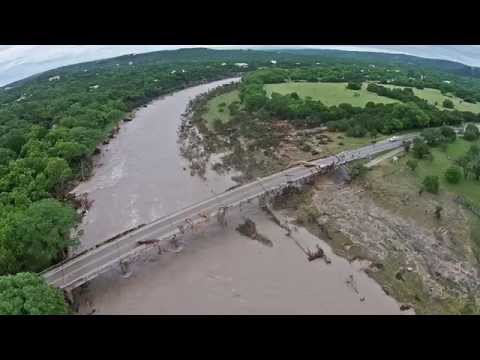
To experience what that translated into along the riverbanks, watch the drone-shot video of damage by Stephen Ramirez, the photographer and videographer from San Marcos, not far away, who contributed to yesterday’s post, as well. He is out doing flood relief today. “It’s truly heartbreaking,” he said in an email.
After Curran read my post yesterday on the intersection of development pressure and extreme environmental hazards in the region, Curran sent these valuable additional thoughts, centering on the reality that growth in the area isn’t going to grind to a halt – and on the need to work hard to integrate science into society’s decisions
I sympathize with the view that it’s all development run amok and we just need to contain it. I tried to convey some of that in the intro to the 2008 article. I love the passion these people feel, but I don’t find it a practical argument. Populations continue to grow and it has been shown time and again that attempting to regulate people to stay away is not effective.
I am enough of an engineer to believe that we can have development and that we can do it better. I work in river engineering, because I want to be part of finding better ways for the built and natural environment to coexist. I think my model from long ago showed that extreme flooding would become increasingly common with development. From the numbers in your article, it looks like there has been quite a lot of increase in urban area. I expect the increase in extreme flood likelihood will occur prior to reaching 73-percent urbanization because of changes in climate.
While I argue for newer, updated modeling, I also jump to what we can do in terms of engineering to reduce major flooding.
First there has to be motivation for it, as you pointed out in the article.
There needs to be something that will motivate people and legislators to act. Sometimes a giant flood will do that. Nashville, Tenn., now has a very impressive flood warning system that didn’t exist prior to the 2010 flooding. [Read coverage in The Tennessean.]
For the Blanco flood, it wasn’t until I was looking at the data and some of the pictures that I understood the scope of the flood. What grabbed me was a photo where it looked like passing floodwaters had stripped the bark from the trees, although the trees were still standing. I hadn’t seen trees de-barked to that level from flood damage since the photos of the Taum Sauk reservoir collapse in Missouri in 2005.
[Read sobering overviews of that incident here and here.]
At this point, the question becomes what we should do differently in development assuming that development will continue despite efforts to reduce it. It becomes a situation of managing flow from development. The regulations are always weak. I’ve been involved in some regulation committee writing which showed me firsthand how they are written to be the final resort.
When I was at the University of Virginia, I would try to emphasize to my civil engineering undergraduate students that designing to meet the regulations was the equivalent of getting at C grade. They are written to be the minimum a developer has to do.
I appreciate the thinking behind this but as it hasn’t resulted in safer communities overall. I would change it and strengthen the regulations.
Focusing on environmental issues is the one stick that seems to work. I wish there were more incentive based approaches that worked and LEED [a widely used environmental standard for buildings] has shown that they are possible, but it’s hard to put a plaque on water that infiltrates into the ground instead of running off from a parking lot.
The Nature Conservancy, city governments, and other groups should continue to purchase land and put as much aside into easements as possible.
The hike and bike trail around Lady Bird Lake in Austin is an excellent example of an amenity that is also a floodplain.
Water collection cisterns on roofs help with both flooding and droughts. If a builder puts in a system that makes the rainwater potable, then that owner reduces stress on the water grid as well as reducing future river flood levels.
There are ways to mitigate a large flood and have some development. We just can’t be idiots about development and end up in a race to the lowest denominator in standards. I would argue that we do better for earthquakes; the same should be the case for floods.
It will be interesting to see if the Federal Emergency Management Agency identifies any of the damaged properties as repeat buyout sites. Overall the system appeared to work as it got a lot of people out of harm’s way in the middle of the night. An interesting note on the people who were vacationing is that they may have seen a flood warning for Hays County and not known what county they were visiting.
I like that some others in your column emphasized that these types of floods will become increasingly likely.
I don’t think there is an amount of storm-water infiltration that would have prevented the flood that occurred – it only would have made it smaller.
The quest then becomes to keep people safe.
With that in mind, I always liked Arizona’s “stupid motorist law” [under which the driver of a vehicle passing flood-warning barriers on a highway has to pay the costs of any rescue].
Curran had suggested the law may have been repealed, but my quick scan of Arizona news sites seems to indicate it’s still on the books.
Pay as you go works for me, too.
Footnote | I found a fascinating monograph on the impact of the Balcones Escarpment on rainstorms that’s worth a look. Here’s a snippet:
Many lives have been lost and much property damage incurred over many years from floods in Central Texas, most of which have been caused by large rainstorms. The meteorological characteristics of Central Texas, along with an orographic influence caused by the Balcones Escarpment, produce conditions that cause large rainstorms in the area.
And there’s an explainer from Texas Monthly.